This is where we keep you up to date with our activities on hyperspectral drone and satellite-based scanning and monitoring for mining. Some of our social posts are highlighted below, head over to our Linkedin page if you don’t want to miss the newest developments. You will also find recent publications, all open access of course, and links to articles.
Publications
Victor Tolentino’s MSc thesis is finished and published. It is situated within M4Mining and Auscope activity, supported by the Geological Survey Queensland. We collected hyperspectral UAV data over the former Uranium mine Mary Kathleen in Northern Queensland including hyperspectral EnMap satellite data over the former evaporation pond and tailing and are investigating environmental surface changes over the sites. His thesis is openly available, you can find it here.

A review paper on “VNIR-SWIR Imaging Spectroscopy for Mining: Insights for Hyperspectral Drone Applications” by Friederike Koerting et al., 2024
With a review on the use of hyperspectral imaging in mining from satellite, airborne and drone platforms. The potential of hyperspectral from drone-based platforms for mining and practical information of field planning, flight planning and processing.
Link to open source publication
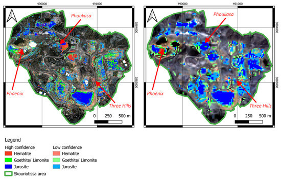

“Drone-Based VNIR–SWIR Hyperspectral Imaging for Environmental Monitoring of a Uranium Legacy Mine Site” by Tolentino et al. looks into hyperspectral drone-borne data collected in formed Uranium mine Mary Kathleen in Queensland, Australia and the potential for monitoring site changes.
Videos
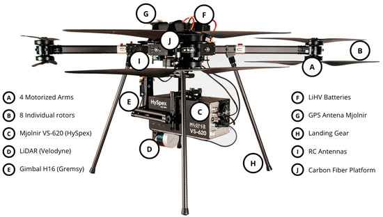
Real-Time Hyperspectral Processing developed by Norsk Elektro Optikk AS (HySpex), NORCE Norwegian Research Centre, ReSe Applications LLC, and Prediktera AB within the M4Mining project. This integrated hardware and software solution is transforming hyperspectral data processing.
- 500MB/s data collection by drone
- Instant surface modeling and georeferencing
- Atmospheric corrections on the fly
- Application-specific analyses (e.g., mineral maps)
- 3D visualization in real-time at the ground station
✨ No Rasterization, No Overhead
Delivering precise results instantly, all visible in real-time—even across continents via satellite links.
Find out how the M4Mining project is progressing in experience and case studies using hyperspectral drone technology for mineral and environmental mapping in mining environments. During a hackathon at NEO’s offices in Oslo in September 2023, the M4Mining project partners from Europe collaborated to integrate hardware and software solutions. Highlights include successful field testing at a quarry near Oslo, where real-time data visualization and 3D terrain mapping showcased the potential of hyperspectral drones in mining operations. Funded by Horizon Europe, M4Mining continues its research and enables the collaboration of the various partners
Funded by Horizon Europe
M4ming is a European Union Horizon Europe collaborative project that aims to improve material characterization during extraction, re-mining, and environmental impact monitoring.
Our core aim is to map and monitor active and inactive mining sites using UAV and satellite sensors. We work to achieve real-time mineral classification via UAV, allowing seamless 3D visualization for decision-makers on the ground. The infrastructure (hardware and software) will be developed through direct conversations with stakeholders on a mineral advisory board.